Coming up Short: The crash of MarkAir flight 3087
On the 2nd of June 1990, a Boeing 737–200 on its way to pick up passengers stranded in the remote Alaskan village of Unalakleet descended into terrain on final approach, colliding with a barren hilltop 7.5 miles short of the runway. Despite the heavy impact, in a stroke of incredible luck all four crewmembers not only survived the crash but were rescued within the hour. That provided the National Transportation Safety Board with an uncommon opportunity to ask the crew those burning questions that all too often go unanswered, having been lost along with the ill-fated pilots of unluckier flights. And in this case, one such question was at the forefront: why did the Captain believe he needed to begin his final descent at a distance of ten nautical miles, when his approach chart clearly said that the descent should begin at five? The answer was a sobering reminder not only that no one is above making silly mistakes, but that those mistakes might not always have an obvious trigger — and that in the fight against human errors, sometimes the best offense is a good defense.
◊◊◊

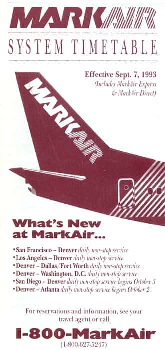
In 1984, Neil Bergt, the eccentric owner of a small Alaskan cargo airline, announced that his company would be reborn as MarkAir, a passenger airline transporting goods and people into the many remote communities scattered throughout the Alaskan frontier. As a business model, the format is tried and true, and plenty of other companies had paved the way already, forming a niche industry apart from the rest of America’s airlines in terms of both geography and culture. And for a little while at least, MarkAir was just another one of these carriers, if such a thing could be said of a group of airlines renowned for operating unusual aircraft types into far-flung, icy places.
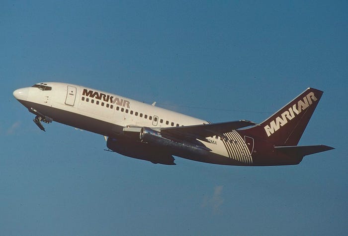
By 1990, MarkAir had grown to become the largest airline operating wholly within Alaska, in large part thanks to its fleet of Boeing 737–200 “combi” airliners. Built between 1965 and 1988, the -200 was the first mass-produced Boeing 737 variant and can be recognized primarily by its long, thin JT8D engines and its short fuselage, which gives the plane a stubby appearance but also contributes to its ability to fly into smaller airports that later, longer 737s would be unable to serve. In Alaska and northern Canada, the 737–200 has a long and storied service history, and as of this writing several are still flying there. Many of these aircraft are specially modified for the arctic operating environment, often by turning them into so-called combination or “combi” aircraft with accommodations for both cargo and passengers on the same deck. The exact combi layout differs not only from airline to airline but from aircraft to aircraft, with the ratio of cargo to passengers varying depending on each company’s needs. The layout is highly effective on flights to remote villages that often depend on air travel but lack enough of a market to fill a dedicated passenger airliner, because a passenger-cargo split allows the airline to replace unused passenger capacity with space for mail and consumer goods that must be shipped in by air.

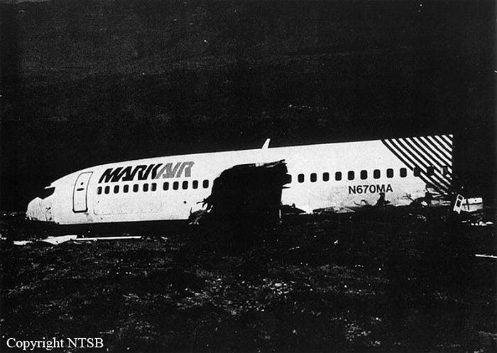
One of the Boeing 737–200s in MarkAir’s fleet in 1990 was N670MA, which was manufactured in 1984 and had been set up in a passenger-heavy combi configuration with a single cargo position in the front and 70 passenger seats in the back. To prevent foreign object damage while operating on unpaved runways, the plane was also modified with a “gravel kit” consisting of deflectors mounted on the landing gear, wheel well shielding, abrasion protection on the flaps and lower fuselage, and vortex dissipaters designed to stop debris from being sucked into the engines. (Part of the enduring popularity of the 737–200 in the arctic has to do with the easy availability of gravel kits, which are a must-have for any turbine aircraft operating into unimproved airstrips.)
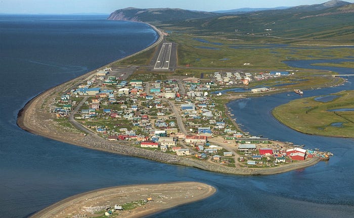
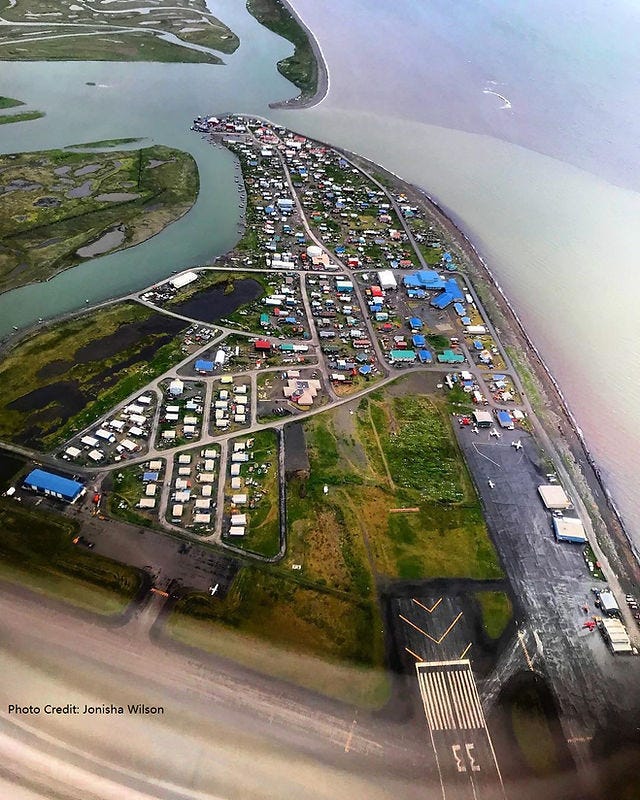
One of the regular destinations served by MarkAir’s 737s was the remote Yup’ik village of Unalakleet, located on the eastern shore of the Bering Sea about 630 kilometers northwest of Anchorage. The village, built on a spit of land at the mouth of the Unalakleet River, is home to about 700 people, mainly Native Alaskans, and has no overland connection to the rest of the state — unless one happens to be participating in the Iditarod sled dog race, in which case the first team to reach Unalakleet by sled wins a prize worth $2,500. From there, it’s only a brief (by Alaskan standards) 400 kilometers to the finish line in Nome.
For most people, however, the only reliable way in and out of the town is by air, via Unalakleet Airport. Today, the airport has two paved runways — one for light aircraft and one for airliners — but in 1990 the main runway was surfaced with hard-packed gravel, which was precisely why N670MA needed a gravel kit.
At that time, MarkAir operated one daily flight from Anchorage to Unalakleet, but residents were well aware that holding a ticket for a specific date did not always guarantee one’s actual day of departure. The flights to Unalakleet were highly weather dependent, and like anywhere on the shores of the Bering Sea, the weather there is often bad. And in the final days of May and first days of June in 1990, the weather was so unpleasant that no flights were able to make it in at all, which was a problem because the local fishing season had just concluded, and there were more than 100 fishermen stranded in Unalakleet in desperate need of transportation back home to other parts of Alaska.
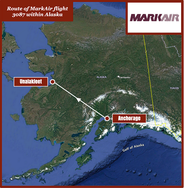
By the 2nd of June, MarkAir’s regular flights had been cancelled for several days in a row, and resources were under strain in Unalakleet, which has limited overnight lodgings and certainly did not have room to properly accommodate over 100 visitors for any length of time. Therefore, when the weather lifted slightly on the 2nd, MarkAir arranged to send not one but two 737s to pick up the stranded passengers. One of these would be MarkAir flight 87, the regularly scheduled daily round trip, while the second, flying just ahead of it, was to be the “extra section” flight 3087, which would fly empty from Anchorage to provide extra capacity.
Four crewmembers were rostered for the special flight 3087, consisting of two pilots and two flight attendants. In command was 39-year-old Captain Glenn Smith, who had 12,000 hours of experience flying not only for MarkAir, but also for the United States Air Force and the Alaska Air National Guard, where he still regularly flew the Lockheed C-130 Hercules. (As an interesting aside, he had also flown the rare civilian version of the C-130, called the L-100, for MarkAir before moving to the 737.) More than half his flying time was on the 737, both the civilian and military versions, and he had flown to Unalakleet several times before. By contrast, his 28-year-old First Officer Robert Fell was far less experienced, with only 1,800 total hours. He had been hired at MarkAir in February of that same year; had only 80 hours on the 737, which was the first jet he had ever flown; and had just finished his supervised Initial Operating Experience on May 12th. This would be just his second time flying to Unalakleet.
Also on board were the two flight attendants, 26-year-old Sonia Nelson and 21-year-old Michelle St. Amour, who planned to ride along in the cabin. The plane was otherwise empty, except for a pallet of soft drinks occupying the cargo position.
◊◊◊
After a nearly 40-minute departure delay due to persistently low cloud ceilings in Unalakleet, flight 3087 finally departed at 8:28 a.m. and proceeded northwest at 31,000 feet with an estimated en route time of one hour and nine minutes. As they cruised, the cockpit voice recorder captured Captain Smith giving First Officer Fell some pointers on the use of the flight management system, and coordinating their plans both with company ground personnel in Unalakleet and with the crew of the regular flight 87, which was about 10 to 15 minutes behind them. Over the radio, Smith expressed concern that there wasn’t enough space on the ramp to park two 737s at the same time, and there was some wrangling over who would get the regular parking spot and who would have to squeeze in elsewhere. The ground representative stated that he hoped to have flight 3087 ready to taxi by the time flight 87 arrived, but with only 15 minutes between them, that would be an exceptionally fast turnaround.
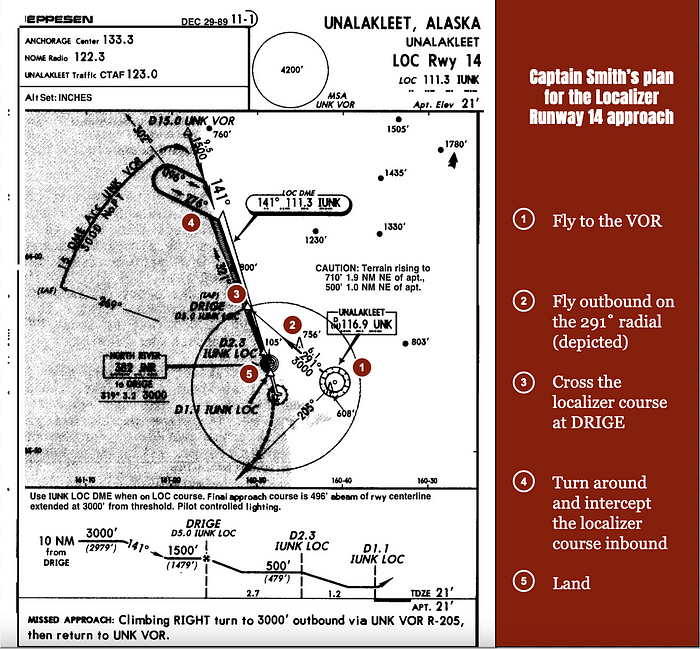
Minutes later, at 9:14, Anchorage Center cleared flight 3087 to begin descending to 8,000 feet, and as they headed down, Captain Smith took the opportunity to brief the approach to Unalakleet. The plan was to accomplish a non-precision localizer approach to runway 14 from the north. On this approach, a localizer was in place to help the plane align with the runway, but the airport lacked a glideslope system to provide automatic guidance in the vertical plane (hence the “non-precision” designation).
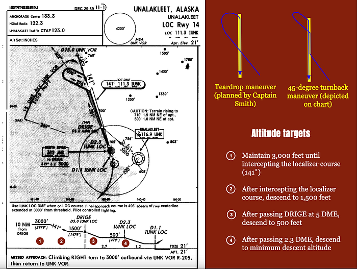
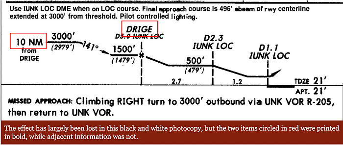
Referring to his approach chart, which is shown above, Smith planned to fly first to the Unalakleet VOR (Very high frequency Omnidirectional Range) radio beacon, known by the abbreviation UNK, and then proceed outbound, away from the airport, on a heading of 291 degrees, which would cause them to cross the localizer course at the waypoint DRIGE. From that point, the approach chart suggested making a right turn to follow the localizer course outbound, followed by a 45-degree left turn, a 180-degree right turn, and a 45-degree right turn to reverse course and land, crossing back over DRIGE again on the way down. However, Captain Smith announced that his plan was to continue outbound on 291 degrees after crossing DRIGE, then turn inbound and intercept the localizer in one, big, sweeping turn. This is known as a teardrop maneuver, because the ground track of the airplane resembles a teardrop, as shown below.
That was the horizontal plan, but because this was a non-precision approach without vertical guidance, they also needed a vertical plan. To this end, their approach chart provided minimum target altitudes at various stages of the approach, measured in terms of DME.* DME, which stands for distance measurement equipment, is used to describe the distance in nautical miles between said equipment, which is usually located somewhere on the airport grounds in line with the runway, and a given location on the localizer course. DME receivers on board the aircraft pick up signals sent out by the distance measuring equipment and display that distance to the pilots, helping them understand where they are in the approach.
Reading off the minimum altitudes listed for each stage of the approach, Smith explained that they would stay at or above 3,000 feet until turning inbound. Then they would descend no lower than 1,500 feet before reaching waypoint DRIGE, then no lower than 500 feet by 2.3 DME. After that, they were free to descend to the minimum descent altitude of 360 feet, which they were to maintain until the runway was in sight. Notably — and this will become important later — Smith didn’t mention that waypoint DRIGE was located at 5 DME.
Continuing the briefing, Smith went on to explain the missed approach procedure, when they would extend the flaps, and what autobrake setting they would use. He then told First Officer Fell to start the auxiliary power unit at 5,000 feet to make sure it was running by the time they landed, because Unalakleet didn’t have auxiliary ground power, and instructed him to switch off engine bleed air on final approach. This was part of the gravel runway procedure, designed to ensure that rocks and debris would not be ingested into the bleed air system, which diverts air from the engines to pressurize the cabin.
Throughout the entire briefing, First Officer Fell repeatedly said “okay” to indicate that he was listening.
Concluding the briefing, Smith then added, “Standard callouts, see anything you don’t like or anything you question just feel free to call it out.”
“Okay,” said Fell.
“I’ve been known to screw up on a regular basis,” Smith jokingly added.
“You’re not the only one,” said Fell.
“Hopefully that’s why there’s two of us up here,” Smith said.
“That’s right, that’s the whole idea behind it,” Fell agreed.
*Note: Non-precision approaches no longer use this descent method, known as “dive and drive.” Today, pilots calculate a continuous descent angle instead of descending in steps.
As flight 3087 descended further, flight attendant Sonia Nelson arrived in the cockpit and sat down in the jumpseat to observe the landing and learn the turnaround plan. “Michelle’s writing a letter,” she said as she entered, explaining that her colleague Michell St. Amour would remain seated in the rearmost row of passenger seats instead of joining them in the cockpit.
Turning to Nelson, Smith said, “They are going to try to put us out first, see with fifteen minutes they are going to try to load this thing ASAP and hopefully have at least half of it loaded before [flight 87] even gets in, which I think they are being real optimistic.”
“I think they are,” said Nelson.
“Those guys are only about — ” said Smith.
“Unless they have some agents down here from Anchorage or something, I doubt…” Nelson continued.
“They are only ten to fifteen minutes behind us too,” said Smith. “I tried — I wanted to get [flight 87] out of there first, park where that way they could load them up, we’d take the excess and go on home at our leisure.” The other crewmembers laughed. “But no such luck,” he added.
Thereafter, the pilots completed the descent checklist, discussed the plan to start the APU, and signed off with Anchorage center to contact approach control in Nome.
“Markair thirty eight seven, Nome radio, good morning” said the new controller. “Unalakleet latest weather report estimated ceiling five hundred [feet] overcast, visibility one and one half [miles] in fog, temperature four eight [degrees Fahrenheit], dewpoint missing, wind calm, altimeter two niner niner four.”
“Good copy, thanks,” Fell replied. With the cloud ceiling at 500 feet and 1.5 miles of visibility, the conditions were above the minimums for landing. The temperature of 48˚F (9˚C) was right about average for Unalakleet in June, and the pilots were pleased to note that it was warm enough they wouldn’t need to turn on their anti-icing equipment.
Moments later, flight 3087 reached the UNK VOR, still descending, and they launched into the approach plan. Captain Smith announced that they were proceeding to 3,000 feet and instructed First Officer Fell to tune in to the frequency for the runway 14 localizer. Smith then steered them outbound on a heading of 291 degrees, exactly as planned, and about 90 seconds later they reached the localizer course in the vicinity of waypoint DRIGE.
Continuing straight ahead across the localizer and out to sea, Smith called for flaps one, then flaps five, and finally flaps 10. Then, after about two minutes, he announced, “Coming right,” and began the sweeping right turn to complete the teardrop maneuver and intercept the localizer course for landing.
Seconds later, as the plane reached 3,000 feet, Smith said, “Going to fifteen hundred inbound,” and continued the descent.
“Checks,” said Fell.
“Fifteen till ten DME,” Smith added.

If you paid close attention to the earlier description of the approach procedure, you might have already recognized that Smith was mistaken. The official procedure was to remain at 3,000 feet through the procedure turn, then descend to 1,500 feet and proceed to DRIGE, at which point further descent was permitted. But DRIGE was located at 5 DME, not 10 DME, so Smith’s statement that they should hold “fifteen till ten DME” was clearly incorrect. It wasn’t what he had briefed, it wasn’t what was depicted on the approach chart, and it wasn’t safe. So where did the misconception come from? A whole team of investigators, and Smith himself, would later spend months trying to answer that very question. But in that moment, for whatever reason, it passed completely unquestioned by either pilot.
Continuing the descent toward 1,500 feet, Smith called for landing gear down, flaps 15, the before landing checklist, flaps 25, and finally flaps 30, the landing configuration. As they approached the localizer, First Officer Fell called out, “Localizer’s alive, on the right.”
“Fifteen hundred to ten, what we’re shooting for,” Smith repeated.
And again, instead of correcting him, Fell simply said, “Okay.”
Moments later, Fell called the landing checklist complete, and Smith said, “There comes the ten to fifteen hundred — five hundred feet is what we’re headed for.” At this point they were descending through 1,700 feet and should have been preparing to level off at 1,500 feet until reaching DRIGE at 5 DME. But because Smith had gotten it into his head that they would descend to 500 feet at 10 DME, they kept going.

Now fully aligned with the localizer and just a couple minutes from landing, Smith said to Fell, “And go ahead and switch the bleeds,” referring to the bleed air system, as he had briefed.
“What, do I bring them off here? Alright,” said Fell. He reached up to the overhead panel where the bleed air switches were located and began the six-step reconfiguration process.
An altitude alert chime sounded, and Smith announced, “There’s a thousand [feet].”
“A thousand above the field,” Fell called out. “Altimeters and instruments cross-checked, no flags.”
“Go ahead and hit ’em, five clicks or whatever for the lights, make sure they’re on when we come out of the bottom here,” Smith instructed. Because Unalakleet had no control tower, the runway lights were pilot-controlled and could be activated by repeatedly pressing the VHF microphone key while tuned to the airport frequency.
Several clicks were then heard as First Officer Fell brought up the runway lights, but the runway itself was not yet visible. Nevertheless, as they descended closer to the cloud base at 500 feet, some gaps began to appear below them, and Fell called out, “Ground contact.”
“Okay,” said Smith.
One second later, Fell suddenly caught sight of something through the fog ahead. He found just enough time to exclaim “Oh — ,” and then, 7.5 nautical miles short of the runway and descending through 530 feet, flight 3087 crashed into the ground.

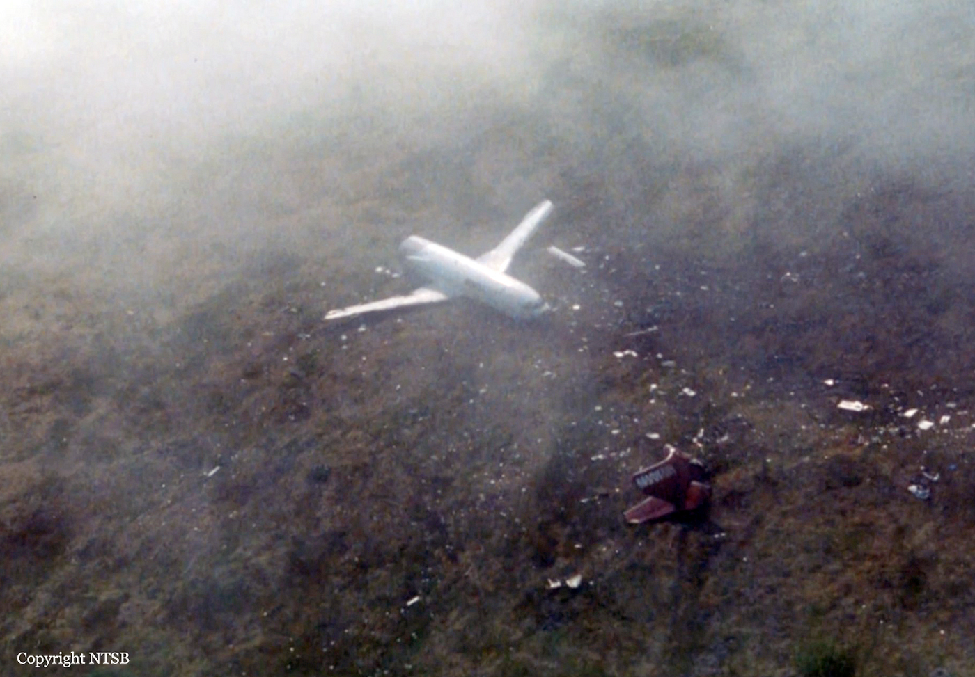
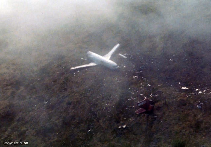
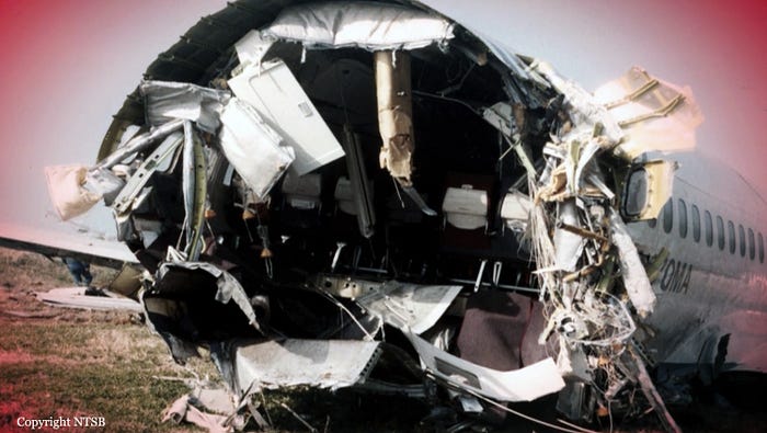
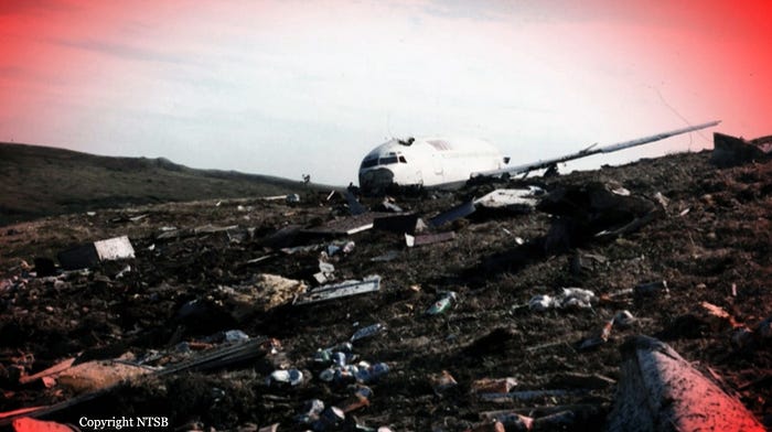
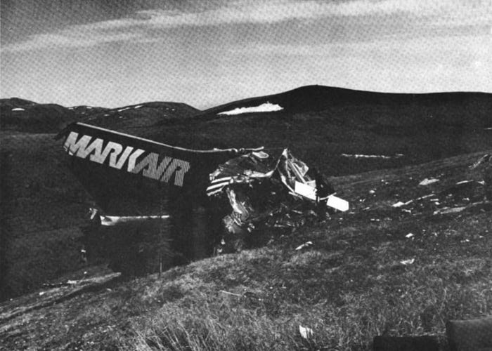
The cockpit voice recorder captured a cacophonous noise as the plane, clipping several alder bushes, plowed into the gently sloping flank of the 700-foot Blueberry Hill, then it cut to silence. The landing gear collapsed and the fuselage impacted heavily; the plane bounced, and the tail section ripped away, tumbling across the tundra as debris flew in every direction. Minus the tail, the rest of the airplane hurtled forward, spinning around almost 180 degrees as it careened up the hillside, tearing away chunks of the lower fuselage while skidding over the rocky terrain. Finally, traveling almost backwards, it slid to a halt, heavily damaged, but, for the most part, intact.
In the cockpit, both pilots and the flight attendant in the jumpseat found that they had survived the crash with minimal injuries. Damage in the cockpit was moderate; a few instruments had shattered and the cockpit door area was badly deformed, but there was no sign of fire. The forward cabin was also mostly intact, although soft drink cans were scattered everywhere. After taking stock of the situation, all three crewmembers escaped via the cockpit windows and set about searching for the other flight attendant, the 21-year-old Michelle St. Amour, who had been seated in the very back of the plane. Although none of them have ever provided detailed public accounts of the immediate aftermath, one can only imagine their horror upon discovering that the tail section, including the last two rows of passenger seats, was no longer attached to the airplane at all. The bright red tail, emblazoned with the MarkAir name, lay just beyond and slightly downhill of the nose, but St. Amour was not there, nor were any of the missing seats. Instead, they found her well back along the wreckage trail, sitting upright in her seat with the seatbelt fastened, alone on the tundra, dazed and injured, but somehow alive.*
*Note: The official report doesn’t clarify by whom she was found. However, it seems probable that the other crewmembers would have located her, given their minor injuries and the time available for them to search before being rescued.

Meanwhile in Unalakleet, it took about 10 to 15 minutes for ground crews to realize that flight 3087 was overdue and could not be raised by radio, and that something terrible must have occurred. A plan was quickly enacted to search for the plane by helicopter, but no search and rescue helicopter was on standby, and it took almost 45 minutes to get one ready. Once underway, keeping beneath the cloud base, the helicopter began the search with a sweep of the inbound localizer course to runway 14 — and almost immediately encountered the wreckage of flight 3087, its white fuselage lying ghost-like on the hillside amid the fog, a sight almost eerie in its incongruity.
Having reached the crash site about an hour after the accident, the helicopter landed, gathered the four crewmembers, and departed again within 15 minutes. As far as rescues in Alaska go, it was probably one of the fastest — and all were no doubt glad that it was so, considering the seriousness of St. Amour’s injuries. Suffering from a fractured skull and injuries to her neck, she was airlifted to a hospital in critical condition, but thanks to the swift work of the rescue crews and medical personnel, she ultimately survived.
◊◊◊
The following evening, investigators from the National Transportation Safety Board arrived at the remote crash site to begin their investigation, recovering the black boxes and interviewing the crewmembers.
The flight data recorder showed quite clearly that this was a simple case of controlled flight into terrain: the crew had begun their descent to 500 feet several miles too early, and collided with a 700-foot hill north of the runway. Furthermore, the cockpit voice recording showed that Captain Smith thought he could descend to 500 feet at a distance of 10 DME, even though in his briefing he stated that this descent would occur at DRIGE, which was at 5 DME.
In many similar accidents, the NTSB can only speculate about what the pilots were thinking. This time, however, the crew were alive and well, and could be asked the simple question: why did they descend so early?
There was just one problem: Captain Smith didn’t know the answer either. In his initial interview, he said that as far as he knew he had flown the approach as published, and that he had no idea what went wrong. Only after the NTSB invited him to listen to the cockpit voice recording did he realize what had occurred. But even then, he was unable to say why he thought the descent should take place at 10 DME, when the approach chart clearly showed it at 5 DME. This wasn’t an intuitive mistake, and there wasn’t some smoking gun that would explain it. It was as though a different number simply wormed its way into his brain and implanted itself there without his knowledge.
In a speculative effort to resolve this basic conundrum, the NTSB came up with several possible but somewhat far-fetched explanations for his mistake.
The first of these had to do with the formatting on the profile view depicted on the approach chart. In this part of the chart, the words “10 NM from DRIGE” were written at the beginning of the profile, where the inbound portion of the approach was to be initiated. Because the words “10 NM” and “DRIGE” were written in a larger font than the word “from,” one remote possibility was that Smith somehow failed to notice this smaller word and came to believe that DRIGE itself was at 10 NM, or 10 DME. Another equally unlikely theory held that his brain somehow associated the words “10 NM” with the label depicting DRIGE further down the profile because both were in bold, while other parts of the profile were not. Either of these interpretations would have been a freak error with little justification in the design of the approach chart, which was perfectly straightforward in its depiction of the steps and distances. Nevertheless, after six months of no-doubt painful self-examination, this was Captain Smith’s own best guess as to what happened.
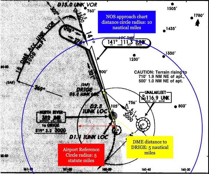
Alternatively, the NTSB slightly preferred a third theory, although not by such a margin as to reject the others. According to this theory, Smith’s unconscious error arose from the fact that he used Jeppesen brand approach charts while flying for MarkAir, and National Ocean Service (or NOS) approach charts while concurrently flying for the Alaska Air National Guard. Most NOS approach charts included a circular “distance ring” overlaid on the plan view portion of the chart, usually centered on the airport with a radius of 10 nautical miles, whose purpose was to indicate that everything inside the circle was to scale. At the same time, Jeppesen charts included an “airport reference circle” with a radius of 5 statute miles, also centered on the airport, whose only purpose was to draw the viewer’s attention to the airport’s location.
At Unalakleet, the DME system was installed beyond the south end of the runway, while the airport reference circle was centered a few thousand feet to the north. Therefore, for the runway 14 approach from the north, waypoint DRIGE at 5 nautical miles from the DME also happened to be 5 statute miles from the airport center (one nautical mile being 1.15 statute miles), such that the airport reference circle coincidentally intersected the localizer course precisely at DRIGE. It was therefore possible that as he repeatedly glanced at his approach chart during the descent, Captain Smith unconsciously interpreted the airport reference circle as a 10-nautical-mile distance circle, and thus mentally placed DRIGE at 10 DME instead of 5.
Considering this possibility, the NTSB recommended that the FAA work with other parties to standardize the use of circles on civilian and military approach charts.
◊◊◊
Working through the sequence of events step by step, the NTSB started to see how the groundwork was laid for this error. Although the approach briefing was mostly standard, it would have been prudent to mention the DME distance of DRIGE, which Smith did not do. If he had said DRIGE was at 10 DME, then First Officer Fell, who was looking at his own copy of the approach chart, might have corrected him. Alternatively, if he had correctly specified 5 DME, then he would have been less likely to forget this number later.
The NTSB also noted that Smith didn’t explain how far he planned to extend the teardrop maneuver or how he would determine when it was time to turn inbound, which made it harder for First Officer Fell to monitor their progress. Then, once in the teardrop maneuver, he called for a descent from 3,000 feet to 1,500 while still more than 90 degrees off from the localizer course, whereas the approach chart indicated that the descent to 1,500 feet should not begin until established on the localizer. This deviation was consistent with a belief that DRIGE was at 10 DME, because the teardrop maneuver would cause them to intercept the localizer close to this distance. If DRIGE was in fact at 10 DME, then there wouldn’t have been enough time to lose 1,500 feet before reaching it unless the descent was initiated while still in the turn.
It’s worth noting that following the course reversal procedure shown on the approach chart, as opposed to the teardrop maneuver actually executed, probably would have resulted in a clearer picture of their DME distance throughout the outbound and inbound portions of the approach. MarkAir management also stated that they didn’t condone using teardrop course reversals unless called for by the approach chart, but MarkAir line pilots interviewed by the NTSB disagreed that there was any such company policy. Regardless of whether this was the case, the NTSB believed that Smith likely chose to perform the teardrop maneuver because it resulted in a shorter ground track and therefore saved time.
All of the above facts serve to show that Captain Smith lost awareness of the locations of key points, and/or his own location relative to them, sometime during the teardrop turn. Small omissions in the approach briefing, imprecise planning of the teardrop maneuver, and general time pressure possibly contributed. However, one thing the NTSB report doesn’t address is whether a descent to 500 feet at 10 DME should have struck him as unreasonable from the beginning. All things considered, this is quite far out to be descending that low, especially on an approach over uneven terrain. It’s possible that Smith routinely flew to airports where the DME was not co-located with the airfield, in which case the runway itself might be at one or two or three DME, and a low descent at 10 DME might be more reasonable, but I don’t have any evidence of this. Furthermore, I reviewed a number of non-precision approaches while researching this section and did not find any that call for a such a low descent so early. Either way, it seems like something that should have caused him to second guess himself, but for whatever reason he didn’t.
Alternatively, if Smith didn’t second guess himself, then it was First Officer Fell’s job as pilot monitoring to do it for him. And yet at no point did he detect that they were descending too early, despite the fact that Captain Smith stated his intent to do so on three separate occasions. One possibility was that he recognized the error but was hesitant to speak up; however, this theory was rejected. Just minutes earlier, Smith had emphasized the principles of crew resource management by making it clear that he was not immune to mistakes and that Fell should question anything that seemed wrong. There was thus no reason why Fell should have been the least bit uncomfortable about speaking up.
Instead, Fell himself pointed a finger at his workload during the approach. He told the NTSB that because he was new to the Boeing 737, every routine task took longer and occupied more of his attention than it would for someone with more experience. Throughout the period in which Captain Smith made his mistake, Fell was completing checklists, responding to calls to extend the flaps, activating the runway lighting, and other routine tasks. Furthermore, right before they reached 1,500 feet, he was told to reconfigure the bleed air system for the landing on gravel. Fell stated that he was not entirely comfortable yet with this multi-step task and that it took his attention away from monitoring their position at a critical phase of the flight. The NTSB agreed that 1,700 feet on final approach was not an appropriate time to be performing a task that realistically could be accomplished much earlier, at a stage of the approach with lower stakes. Furthermore, Boeing guidance for landing on gravel runways stated that this should be done before reaching 10,000 feet, for precisely this reason. In interviews, however, MarkAir management stated that it was company policy to close the bleed air system below 5,000 feet, and often at 2,000 feet or lower, because at higher altitudes it could cause abrupt changes in cabin pressure that would be uncomfortable for the passengers. In the NTSB’s view, this was not sufficient reason to occupy the monitoring pilot with an extraneous six-step procedure during an already high-workload period.
The NTSB also noted that Fell had not yet begun MarkAir’s crew resource management training program, and that even if he had, it didn’t teach strategies that would have helped him effectively monitor key parameters while also carrying out other duties of the non-flying pilot. As I’ve mentioned in previous articles, monitoring instruments and cross-checking parameters is not something humans are inherently good at, and it’s difficult to do either effectively without specialized training. Certainly, a better and more consistent instrument scan, with cross-checks against mental progress gates, could have allowed Fell to detect that Smith was descending too early. But he hadn’t been taught how to do this, and in the event he never connected the dots.
Even with all of this having occurred, a timely terrain warning could have saved them, but no alert was ever generated.
The accident airplane N670MA was equipped with an early generation Sundstrand Mk II GPWS that did not come with a built-in terrain and airport database like the modern Enhanced Ground Proximity Warning System, which didn’t exist yet in 1990. An EGPWS with a terrain database, like those in use today, would have sounded warnings well in advance, and this crash most definitely would not happen in 2023 for that very reason. But the older GPWS in use at the time could not look ahead of the aircraft, did not “know” the locations of airports, and could only measure the proximity of, and closure rate with, the terrain directly beneath the airplane. Therefore, to prevent terrain warnings from sounding every time the plane came in for a landing, the system would not generate “TERRAIN” or “PULL UP” warnings if the aircraft was in the landing configuration with the gear down and the flaps fully extended. If the plane was following a glideslope signal, a premature descent would still generate a “GLIDESLOPE” warning, but there was no glideslope at Unalakleet. Additionally, an excessive closure rate with the ground would still generate “SINK RATE” warnings, but flight 3087 descended into terrain at a perfectly normal pace, so this warning envelope was also never triggered.
The NTSB noted that the latest GPWS version available, the Sundstrand Mk VII, included built-in altitude callouts at 500 feet above the ground and at the “minimums” preset by the crew. If the accident airplane had been equipped with a Mk VII GPWS, the system would have called out “five hundred” about 13 seconds before impact, followed by “minimums” at 8 seconds before impact. It was possible that these callouts would have alerted the crew to the fact that they were closer to the ground than expected. But given that these callouts are generated on every final approach, and that Captain Smith thought he had already passed the final approach fix at DRIGE, it’s possible that they would have been completely expected, in which case he likely wouldn’t have noticed a discrepancy in time to prevent the crash. And in any case, while MarkAir had ordered Mk VII GPWS equipment for its fleet, the devices had not yet arrived.
◊◊◊
Following the crash of flight 3087, MarkAir embarked on an ambitious and at times absurd corporate trajectory that is worth discussing before we move on, for general interest if nothing else. At the time of the accident, MarkAir was engaged in a lucrative feeder agreement with Alaska Airlines that gave it access to the latter’s booking system and allowed it to operate under Alaska branding on certain routes. This was a huge cash windfall for MarkAir, but the airline’s owner Neil Bergt often spent it questionably, paying himself a salary of more than $3 million — and even more extravagantly, in 1988 MarkAir’s parent company built an enormous mansion for Bergt and his wife outside San Diego, and then financed his purchase of it for $6.9 million. Perhaps unwilling to interrupt this generous cash flow, Bergt responded with hostility when, in 1991, Alaska Airlines approached him about renegotiating the terms of the feeder agreement to be more favorable to Alaska. Refusing to agree to the new terms, Bergt offered to sell MarkAir instead, but Alaska Airlines declined the offer.
Incensed at what he must have perceived as unfair treatment, Bergt responded by pivoting MarkAir’s business model almost overnight to compete directly with Alaska Airlines on key routes, beginning in November 1991. This triggered a bloody fare price war with Alaska that continued into 1992, costing both airlines huge sums of money. MarkAir was forced to file for bankruptcy by June 1992, while Alaska Airlines lost a staggering $85 million due to the MarkAir debacle. In a fascinating bit of trivia, this huge net loss was what originally pushed Alaska Airlines’ management to implement the cost-cutting measures that later directly caused the infamous crash of Alaska Airlines flight 261 in January 2000.
As for MarkAir, it emerged from bankruptcy in November 1992, only to pivot once more to services in the Lower 48 states. Subsequently, in 1995 Bergt decided to abandon Alaska altogether, ending all of MarkAir’s operations there and moving its headquarters to Denver, Colorado instead. The move mystified the aviation industry and did nothing to solve the company’s financial problems, and before long Bergt was forced to declare bankruptcy again. A few months later, MarkAir was permanently shut down by the FAA due to poor maintenance.
Nevertheless, throughout all its years of operation, flight 3087 remained the company’s most serious accident.
◊◊◊
All things considered, the MarkAir crash was, compared to many accidents covered in this series, almost banally simple. And yet I chose to write about it anyway not only because of the fascinating context, but because it’s an excellent reminder that no one is above making seemingly inexplicable mistakes. Captain Smith was by all accounts an accomplished airman with extensive experience in all relevant areas and no history of performance problems. Yet somehow, by some unexplained mechanism, he transposed two totally unrelated numbers and flew his plane into the ground. This wasn’t just any error, it was an exceptionally silly one — the kind that makes you say, “D’oh!”
And that’s precisely what makes this case so valuable, as a demonstration not only that anyone can commit errors, but that we can commit very foolish errors that will baffle us later. Whether you’re a pilot or not, it’s helpful to keep that in mind when performing important tasks, because we tend to focus on risks associated with the things we don’t know, despite the fact that an even greater danger sometimes lies with the things we think we know, but actually don’t. One detailed glance back at the approach chart just to be extra certain that everything was correct could have prevented this crash. Explicitly stating the DME distance of DRIGE during the approach briefing, even though it was printed right there on the chart in plain sight, could have prevented this crash. And so on and so forth! There was probably a lot on the pilots’ minds as they prepared for an unscheduled arrival into a gravel airstrip in a remote town with limited infrastructure, followed by a tight turnaround time, concerns over parking, and other exigencies. But it wasn’t any of that stuff that caused the crash. The crash happened because Captain Smith forgot a number. And sometimes, despite everyone’s best efforts, that really is all it takes.
_______________________________________________________________
Don’t forget to listen to Controlled Pod Into Terrain, my new podcast (with slides!), where I discuss aerospace disasters with my cohosts Ariadne and J! Check out our channel here, and listen to our latest episode, in which I learn several different ways to make rockets explode. Alternatively, download audio-only versions via RSS.com, or look us up on Spotify!
_______________________________________________________________
Join the discussion of this article on Reddit
Support me on Patreon (Note: I do not earn money from views on Medium!)
Visit r/admiralcloudberg to read and discuss over 250 similar articles